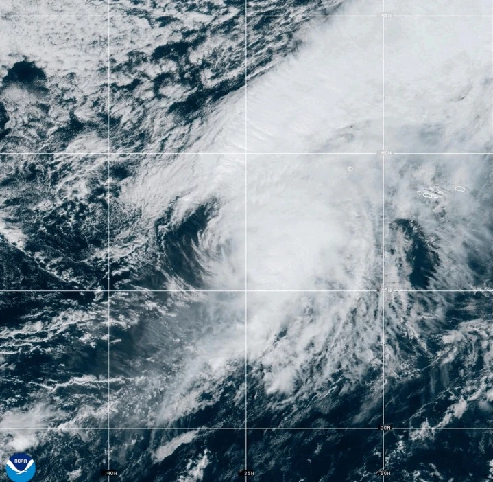
MIAMI (AP) — Hurricane Gabrielle is forecast to impact the Azores Islands starting Thursday night and continue into early Friday, bringing heavy rain and strong winds, according to forecasters from the National Hurricane Center.
A hurricane warning is currently in effect for all islands of the volcanic archipelago, with preparations for the storm needing to be expedited. As of Thursday afternoon, Gabrielle was situated about 455 miles (730 kilometers) west of the Azores, with reported maximum sustained winds reaching 75 mph (120 kph), moving eastward at 32 mph (52 kph).
The storm is anticipated to generate life-threatening surfs and rip currents across the Azores beginning Thursday. Large waves from Gabrielle will also likely impact locations such as Bermuda, the northeastern U.S. coast, and Atlantic Canada.
While Gabrielle is expected to maintain a hurricane status as it traverses the Azores, it is also predicted to show signs of weakening as the weekend approaches. However, significant hurricane-force wind gusts could still affect regions throughout the islands even after the storm passes.
A dangerous storm surge combined with large waves is likely to result in substantial coastal flooding in areas where winds are blowing onshore. Rainfall estimates predict that parts of the central Azores could see accumulations up to 5 inches (13 centimeters), likely triggering flash floods, especially in mountainous locales. Additionally, the eastern and western sections of the Azores could receive about 3 inches (8 centimeters) of rainfall.
Meanwhile, Tropical Storm Humberto, which formed near the Caribbean, was recorded at 465 miles (750 kilometers) east-northeast of the northern Leeward Islands, showing rapid strengthening patterns. The storm is anticipated to develop into a hurricane shortly and may rise to major hurricane status during the weekend.
In the Pacific, Hurricane Narda is positioned about 640 miles (1,030 kilometers) southwest of Mexico's Baja California peninsula, albeit moving away from the coast without any active watches or warnings. Similar to Humberto, Narda is expected to strengthen again and influence coastal conditions significantly with its swells.