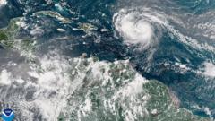
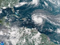
As Hurricane Erin escalates to a Category 4 storm, the eastern United States faces dangerous surf and rip tides. The hurricane is currently impacting the Bahamas and is expected to affect the US coastline with heavy rains and high winds, leading to emergency responses and evacuations.
Hurricane Erin Intensifies, Threatening US East Coast with Dangerous Conditions

Hurricane Erin Intensifies, Threatening US East Coast with Dangerous Conditions
Category 4 Hurricane Erin unleashes potential life-threatening surf and rip currents, prompting evacuations and preparations along the US East Coast.
Hurricane Erin has rapidly intensified to a Category 4 storm, raising alarms along the eastern coast of the United States as it brings the threat of life-threatening surf and hazardous rip currents. The storm's impacts are already being felt in the southeastern Bahamas and the Turks and Caicos Islands, where tropical storm warnings are currently in effect.
Despite not being forecast to make landfall in these areas, Erin is projected to deliver significant rainfall, with estimates reaching up to six inches (15.2 cm) for the Turks and Caicos and eastern Bahamas. Erin marks the first hurricane of the 2025 Atlantic season and showed a pattern of explosive intensification on Saturday, achieving Category 5 status before experiencing a slight decline but has since regained momentum.
In Puerto Rico, over 150,000 residents were left without power as high winds downed electricity lines. The local energy company, Luma, reported that emergency repairs were underway and that by Sunday evening, 95% of the power supply had been restored to customers.
The outer rain bands of Erin have begun to affect the Bahamas, according to updates from the US National Hurricane Center (NHC). Even though a direct hit on the islands is not expected, the Bahamas' Disaster Risk Management Authority has advised residents to prepare by identifying nearby shelters and alternatives. Aarone Sargent, the authority’s managing director, emphasized the unpredictable nature of storms, stating, "These storms are very volatile and can make sudden shifts in movement."
NHC forecasts suggest that the core of Erin will veer to the east of the southeastern Bahamas today, moving between Bermuda and the US East Coast mid-week. The hurricane is expected to maintain its status as “a large and dangerous hurricane” throughout this period.
Authorities in the Outer Banks, North Carolina, are already preparing for significant impacts, including heavy surf and high winds, with mandatory evacuation orders issued for Hatteras Island. They warned that the main roadway connecting Hatteras to neighboring islands may become non-navigable.
Forecasters also expressed concerns regarding dangerous rip tides that could extend along the entire US East Coast as Hurricane Erin approaches.


