The New Atlantic hurricane season kicks off with Erin's intense ascension, posing risks of flash floods and dangerous surf conditions along the eastern coast.
Hurricane Erin Surges to Category Five Status: What You Need to Know

Hurricane Erin Surges to Category Five Status: What You Need to Know
Category five hurricane Erin becomes a looming threat over the Atlantic, prompting safety measures and vigilant forecasts.
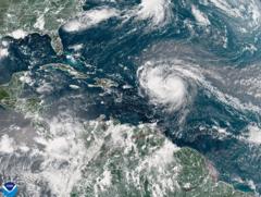
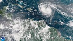
Hurricane Erin has skyrocketed to category five status, demonstrating maximum sustained winds of 160 mph (260 km/h). At a briefing, the National Hurricane Center's Director Mike Brennan described the "extremely powerful" storm as having "explosively deepened and intensified" overnight, transitioning rapidly from a tropical storm earlier in the week. Erin is projected to navigate northward, bypassing the Leeward Islands, the Virgin Islands, and Puerto Rico this weekend, threatening regions with up to 6 inches (15 cm) of rain, which raises concerns about flash floods and mudslides.
The phenomenon known as rapid intensification, where a storm gains strength by at least 34 mph within 24 hours, was notably seen in Erin, as its winds surged from 100 mph early Saturday morning. Looking ahead, reports indicate that Erin will likely drift northward past the Bahamas and head towards the Outer Banks of North Carolina next week. This trajectory poses risks of hazardous surf and rip currents along nearly the entire eastern coastline of the USA, with Florida and the mid-Atlantic states anticipated to experience particularly severe surf conditions.
In light of the gale force winds associated with the storm, the US Coast Guard has begun implementing restrictions for vessels operating within ports located in the US Virgin Islands, specifically in St. Thomas and St. John, along with six municipalities in Puerto Rico, including the capital, San Juan.
As climate change continues to influence weather patterns, the National Oceanic and Atmospheric Administration (NOAA) has indicated an "above normal" expectation for this year's Atlantic hurricane season. They further assess that the frequency of tropical storms reaching category four and five classifications is anticipated to rise due to ongoing global warming trends.


