In a recent turn of events, the U.S. Department of Defense (DoD) announced an extension for essential satellite data access, critical for hurricane forecasting, now set to continue through July 31, rather than the previously slated end date of June 30. The National Oceanic and Atmospheric Administration (NOAA) had earlier indicated that data from three satellites, jointly operated by itself and the Defense Department, would be inaccessible due to unexplained “recent service changes.”
On Monday, NOAA attributed the data halt to concerns surrounding a “significant cybersecurity risk.” However, the decision to prolong data access arose following the intervention of a NASA scientist, demonstrating the urgency of maintaining crucial forecasting capabilities.
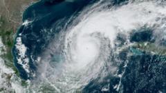
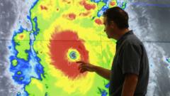
Meteorologists expressed their confusion and alarm over the abrupt announcement, highlighting that the withdrawal of this satellite data would diminish the accuracy of hurricane predictions, thereby heightened risks to lives and properties in the U.S. and beyond. Michael Lowry, a hurricane expert associated with past positions at the National Hurricane Center and FEMA, noted that while the extension was helpful, it still falls short of covering the peak hurricane months of August, September, and October when intense storms are most likely to occur.
Furthermore, the implications of halting the satellite services extend beyond hurricane forecasting. Researchers analyzing polar sea ice dynamics since the 1970s rely on this data for their studies. Sharon Stammerjohn, a senior research associate at the Institute of Arctic and Alpine Research, emphasized the importance of satellite imagery in monitoring seasonal ice melt and refreezing, which plays a pivotal role in regulating global climate by reflecting solar energy. “Without this record, especially in remote Antarctic regions, we risk losing vital insights into climatic changes,” she stated.
While alternative satellite data from agencies like the European Space Agency and Japan Aerospace Exploration Agency could provide some support, Dr. Stammerjohn cautioned that variations in calibration and resolution might pose significant challenges.
As the discussion around these weather-monitoring capabilities continues, it remains essential for stakeholders to address the complexities of data management in the interest of environmental and public safety.