
In brief
A new analysis by BBC Verify indicates that Israeli troops have placed markers to define a boundary in Gaza that is hundreds of meters deeper than what was established in the ceasefire agreement. This move has led to deadly confrontations and confusion among residents about safety zones amid ongoing military operations.
The Israeli military is exerting control over more of Gaza than expected from the ceasefire deal with Hamas, a BBC Verify analysis has found.
Under the first stage of the deal, Israel agreed to retreat to a boundary running along the north, south and east of Gaza. The divide was marked by a yellow line on maps released by the military and has become known as the 'Yellow Line'.
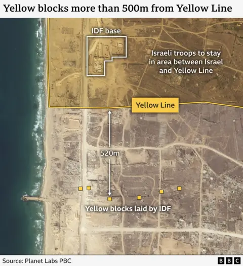
However, new videos and satellite images show that markers placed by Israeli troops in two areas to mark the divide have been positioned hundreds of meters deeper inside the strip than the expected withdrawal line.
Israeli Defence Minister Israel Katz warned that anyone crossing the line 'will be met with fire'. There have already been at least two deadly incidents near the boundary line.
The Israel Defense Forces (IDF) did not address the allegations when approached by BBC Verify, stating simply that: 'IDF troops under the Southern Command have begun marking the Yellow Line in the Gaza Strip to establish tactical clarity on the ground.'
There has been a consistent lack of clarity as to where exactly the boundary will be imposed, with multiple maps posted by various authorities leading up to the ceasefire agreement that came into effect on October 10. Drone footage from the IDF revealed that a line of six yellow blocks was up to 520m further inside the Strip than expected.
A similar situation was visible in southern Gaza, where satellite images showed 10 markers erected near the city of Khan Younis that were between 180m-290m inside the Yellow Line set out by the IDF.
If these two sections of boundary are representative, Israel would be exerting control over a notably larger area than expected from the ceasefire agreement.
Experts suggest that the blocks may be intended to create a buffer zone between Palestinians and IDF personnel, allowing the IDF space to engage potential threats before they reach the established perimeter.
Confusion persists among Gazans regarding the safe areas, with residents expressing concerns in light of recent military actions. The legal status of the boundary remains in question, particularly in relation to Israel's obligations to avoid excessive civilian harm.
The IDF launched a military campaign in Gaza following a deadly attack on October 7, which has since resulted in extensive casualties and humanitarian crises in the region.